
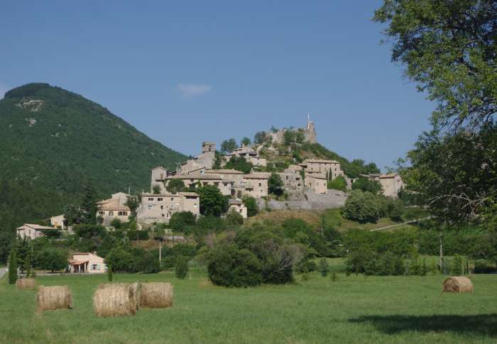
Reilhanette
At the confluence of the Anary and Toulourenc rivers, surrounded by hills, dominated by the ruins of its castle and Mont Ventoux, the medieval village of Reilhanette, also known as "la petite reine", invites you to explore its narrow streets, calades and panoramic views.
La Petite Reine
Nicknamed the "Little Queen", this village has retained an authenticity correlated with its history. Perched on the banks of the Anary and Toulourenc rivers, this fortified place has a past similar to that of Montbrun-les-Bains, visible in the distance. The Reilhanettois quickly developed a self-sufficient lifestyle, focusing on local agriculture (lavender, spelt and coarse wheat). As a firing control post for the French nuclear strike force, the village had a second military life, which has now disappeared.
Get lost in the calades
Calades are cobbled lanes made of flat, well-arranged stones. Narrow and winding, they facilitate the movement of people, carts and animals, minimizing soil erosion. Several of these roads provide access to the castle. They form a dense network of communication routes linking the town's dwellings. Calades are common throughout the Mediterranean region, and Reilhanette is no exception.
Facades that have stood the test of time
The facades of the houses in this village are full of character. While some were altered in the second half of the 19th and early 20th centuries, most have retained their medieval appearance. You'll find semicircular-arched frames with extradosed keystones at the openings. Solid, smooth ashlar surrounds are visible at first glance. Those in gypsum mortar are more prominent at window level.
Extra security!
Dominating the hamlet, the château gives Reilhanette its letters of nobility. Built in the 12th century, it came under the control of the Sire de Montauban in 1276, the Mévouillon and Dupuy families in 1317, and finally the Baronnies du Dauphiné. Today's remains bear witness to its destruction by royal troops in 1560. Since then, many hypotheses have been put forward, such as the location of the entrance gate.
To discover the village :
From the parking lot in front of the town hall, follow the main road towards the village. Cross a square with a fountain.
1- At the first crossroads, take the right-hand lane rising towards the château. Wind between a few houses until you reach the esplanade and the feudal ruins.
2- Make a U-turn and turn right at the first crossroads in the direction of the church. After a few hairpin bends, you come to the porch and entrance to the church.
3- Continue along the calade to rue de la place below. Pass in front of a majestic tree, then descend the staircase just behind it. End up on the village's main road, with the view in front of you.
4- Follow this road to the left for over 200m, until you reach the parking lot in front of the town hall.
- 26570 Reilhanette
-
Spoken languages
French
Updated on 28/08/2026
Through Office de Tourisme des Baronnies en Drôme Provençale
